Towers, Traffic, and Taxes
Key Takeaways:
The pro-developer Woodinville City Council majority is pushing a massive redevelopment of Downtown that will grow the city by 25%. This growth will be heavily focused near already congested intersections.
The plan will enrich developers by upzoning land and creating a new district centered around the politically motivated Eastrail trail system. MRM Capital, the largest landowner in this area, intends to build high-rise towers.
The King County Affordable Housing Committee (AHC) admonished the City for its plans to build economically segregated housing in an industrial area and its refusal to require affordability in other areas. This disproportionately impacts Asian, Black, and Hispanic residents.
The City misrepresented this initiative to the US DOT to secure a design grant by arguing that Eastrail will benefit underserved communities and provide options for commuters. In reality, no one lives in the area today and it is infeasible or impossible to reach most eastside cities from the trail.
The City is spending a record-breaking $64.8 million on capital projects in 2025/2026 with 59% focused on Eastrail. An additional $13.5 million (and counting) in cost overruns were revealed after the budget was passed.
An estimated $187.7 million will be needed after 2025/2026 to follow through on plans to build the trail and a recreation center. This could increase taxes by $1,513 or more per year, per family.
Woodinville is facing rapid transformation under a pro-development City Council that prioritizes high-density growth over solutions to rising costs, traffic congestion, and transportation challenges. Instead of addressing these issues, the Council is aggressively pushing forward the Eastrail Mixed-Use (EMU) district, a large-scale redevelopment initiative that will reshape 45 acres of General Business (GB) land at a massive cost to residents and the character of our community.
What is Eastrail and Why is the Council Focused on It?
Eastrail is a 42-mile railroad corridor stretching from Renton to Snohomish. A non-profit organization called Eastrail Partners formed a Regional Advisory Council (RAC) of eastside cities, counties, and other stakeholders in an attempt to convert this corridor into a trail system.
In Woodinville, there is a 1.8 mile section that runs through the heart of our GB district. Without our help and funding Eastrail would end in Woodinville’s Tourist District and a future Snohomish section would be isolated. This created an opportunity for the City Council majority to ingratiate themselves with regional politicians by creating a high-density mixed-use district and spending the majority of the City’s capital improvement budget on frivolous projects to attract developers.
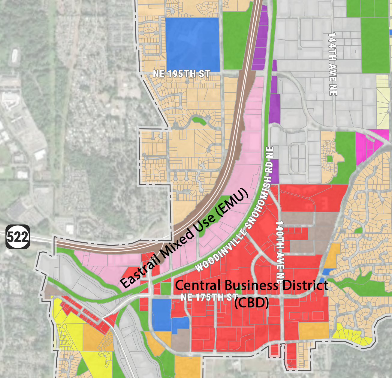
The New EMU Zone
The Eastrail Mixed Use (EMU) zone is a new district of “low- and mid-rise retail, multifamily residential, and professional services in old industrial areas that encourages the mixing of affordable and market-rate developments.” It is situated west of the abandoned railroad tracks that will become the future Eastrail trail.
How does EMU differ from the Central Business District (CBD)? There are very few material differences. EMU is more restrictive in disallowing big box stores and smaller residential developments. The current code for CBD allows 57 ft. mid-rise buildings and assumes a density of 63 homes per acre. For example, the new Eastrail Flats apartment complex on NE 175th St. is a 57 ft. mid-rise. Early communications on EMU make the same 63 homes per acre assumption.
The height restrictions for EMU are not yet defined but MRM Capital who owns more than 30% of this new district is already requesting heights of up to 90 ft.
“Building heights of 85-90 feet are needed for much of the site and flexibility on parking counts will also be needed if this area is to be redeveloped.”
- Letter from MRM Capital, LLC to Woodinville City Council dated April 21, 2024
Investors like MRM Capital are the real winners. Parcels rezoned from GB to EMU could be worth up to 12x based on CBD comparables.
For the full details of the City’s EMU zoning plan, including the letter from MRM Capital, see Development Services Director Grumbach’s Report to the Planning Commission on May 1, 2024.
Economic Segregation
Why would the City create a new district that is nearly identical to CDB and separated by railroad tracks? It’s the City’s response to an expansion of the Growth Management Act (GMA) passed in 2021 that requires it to “identify sufficient capacity of land” to accommodate low income housing. By creating a new CBD-like zone and calling it something different, they can make a frivolous assertion about affordable housing capacity without actually taking any steps to make Woodinville affordable.
Affordable housing is commonly achieved by passing inclusionary zoning that requires a percentage of all new development to be affordable at 40% - 80% of Area Median Income (AMI) and offering incentives to developers who agree to offer greater affordability. The City avoided these strategies because they’re disinclined to make Woodinville affordable and prefer to advance their Eastrail agenda by creating economically segregated housing on the literal other side of the railroad tracks.
King County Councilmember Claudia Balducci, chair of the Affordable Housing Committee (AHC), saw through this ruse and called the City out for its failure to address countywide planning policies, stating that the draft Comprehensive Plan Update does not:
Provide affordable housing throughout the jurisdiction
Promote fair housing policies and practices
Protect and promote the health and well-being of residents by avoiding or mitigating potential exposure to environmental hazards and pollutants.
Respond to findings in the comprehensive plan’s Racially Disparate Impact Analysis Memorandum.
The Racially Disparate Impact Analysis, conducted by Makers Architecture & Urban Design, highlights how Woodinville’s zoning policies have reinforced racial and economic segregation. Asian, Black, and Hispanic residents are largely concentrated in smaller-lot and multifamily housing, while wealthier, predominantly white residents occupy large-lot single-family zones. High lot costs in these areas create financial barriers to homeownership and affordability, restricting access to high-opportunity neighborhoods and deepening existing disparities.
Misrepresentations
By branding this new district EMU and tying it into the new GMA requirements for affordable housing capacity, the Council majority was able to make an argument that the Eastrail connection is crucial to support underserved communities and request federal funding. From the City’s 2024 RAISE Grant application:
“The Eastrail Project will provide safer access to local destinations and the greater regional trail system for residents living in Woodinville’s existing affordable housing developments and those who live well below the median household income levels for the region.” (pg. 167)
The City later argues that Eastrail will benefit the health of underserved communities, despite the fact that the AHC found the plan does not “protect and promote the health and well-being of residents.”
“By completing the Woodinville connection, underserved communities have greater access to improve public health due to increased and equitable access to additional biking, walking, and other non-motorized forms of transportation.” (pg. 168)
The main issue with these statements is that the GB zone has no residential population. Woodinville did not win the RAISE Grant in 2023, which motivated the City to make inaccurate representations about benefits to underserved communities in other neighborhoods to buoy their 2024 application.

Misleading Data
The City Council misrepresented the project’s benefit to underserved communities by showing a graphic with roughly a third of the city shaded in red, indicating that the area is “>40% below median income.” This is a measure of income disparity and does not indicate whether a census tract is underserved.
Smoke, Mirrors, and Trails
Eastrail is more a political aspiration than it is a functional and contiguous trail system. Another misrepresentation the City made to US DOT is that the project “connects underserved communities from the City of Renton to the City of Snohomish” (pg. 167). The Snohomish section does not exist (construction “TBD”) and Woodinville has no way of connecting to the Kirkland section. This eliminates any possibility of reaching Renton until King County delivers their remaining sections. As of now there is no plan. The only completed sections of Eastrail are in Kirkland, part of Bellevue, and Newcastle.

What Are We Actually Connecting To?
The Eastrail connection that the City is promising is just a linear park connecting the future EMU zone to Wilmot Gateway Park where pedestrians can connect to the existing Sammamish River Trail (SRT). From there, pedestrians and bicyclists can reconnect with Kirkland’s Eastrail section in Woodinville’s Tourist District.
Traffic Impact
Woodinville’s 2044 target for affordable housing capacity is 1,813 homes. This represents a 25% citywide increase in a district that makes up only 2% of the city’s total land area. Its proximity to the SR-202 and SR-522 interchange is expected to worsen existing traffic congestion, quickly utilizing the two new lanes added through the decade-long trestle removal and SR-202 expansion.
The City believes that Eastrail will mitigate this traffic. They argue that it provides a viable alternative to driving because it cuts through the highest traffic parts of the city and connects residents to major employers in Kirkland, Redmond, and Bellevue. There is no data to support this assertion. Woodinville’s distance from these cities makes it infeasible for all but the most avid cyclists to use Eastrail as a commuter route. For example, consider the following trips at 7 am on a weekday:
Wilmot Gateway Park to Kirkland (Feriton Spur Park):
Walking: 2 hours 53 minutes
Cycling: 45 minutes
Driving: 20 minutes
Transit: 40 minutes
Wilmot Gateway Park to Bellevue (Wilburton Station):
Walking: 4 hours 22 minutes
Cycling: 1 hour 7 minutes
Driving: 26 minutes
Transit: 1 hour 4 minutes
These trips are only viable 150 days per year, unless you’re fine riding or walking through the rain for long distances. Redmond and other cities along Eastrail are omitted because there isn’t a contiguous path.
There’s one other problem: The King County section of Eastrail that connects SRT to Kirkland’s Eastrail is 1.5 miles of gravel with no plan to improve. In total, the County owns 3.5 miles of unimproved Eastrail segments between Woodinville and Kirkland.

Gravel Eastrail trailhead in King County, connecting Kirkland to Woodinville.
Eastrail offers recreational benefits, but its value to Woodinville is limited. The city’s distance from Kirkland and Bellevue makes it impractical for commuting, and the Sammamish River Trail already provides similar connectivity.
Spending, Stolen Land, and Taxes
Woodinville’s Eastrail spending is massive. In 2025/2026, the City plans to spend a record breaking $64.8 million on capital projects, of which 59% ($38.3 million) is allocated to Eastrail. Here are some of the more egregious projects, listed by net cost after deducting grants and developer contributions:
Design work for Eastrail Multimodal Trail
Details: Design a 1.8 mile linear park between the Sammamish River and the Snohomish County line. Does not include construction or the connection to Kirkland.
Cost to Woodinville: $2,100,000
Funded by RAISE grant reimbursement: $5,000,000 (assuming no rescission by the new administration)
133rd Grid Rd Ext. Intersection
Details: Elaborate roundabout that connects 133rd Ave NE, Woodinville-Snohomish Rd, and Little Bear Creek Pkwy. It includes an underground tunnel that connects two sections of the future Eastrail linear park.
Cost to Woodinville: $8,071,000 (based on the 2025/2026 budget)
Strategic Land Acquisition
Details: Eminent domain of three GB parcels that the City plans to give to the Northshore Parks and Recreation Service Area (NPRSA) to build a community center for Bothell, Kenmore, Woodinville, and surrounding areas.
Cost to Woodinville: $6,000,000 (based on the 2025/2026 budget)
Unfunded: $10,000,000+ (cost escalation discovered after the 2025/2026 budget)
Both the “133rd Grid Rd Ext. Intersection” and “Strategic Land Acquisition” are facing cost overruns. Public Works Director D’Souza reported that City staff is anticipating the grid road extension and roundabout to cost $3.5 million more than anticipated in the 2025/2026 biennial budget that was just approved two months prior.

133rd Ave NE grid road extension and roundabout.
The recreation center land acquisition is also facing a cost overrun. The City planned a $6,000,000 expense because they believed that the landowners would willingly sell when faced with the threat of eminent domain. One might call this “extortion” if it wasn’t committed by the government. Landowners realized that the EMU rezone would increase the value of their properties and they held out for a better deal.
The City is now offering an additional $10,000,000. Since we have not budgeted this added cost, the offer is structured as an option to purchase at a future date. Realistically, the landowners have no choice and are not compensated for giving the City this “option.” This is arguably worse than an outright taking by eminent domain.
Future Tax Increases
2025 is an election year, which means that the Council majority will do their best to avoid and bury discussions of tax increases. There are two major initiatives that will require a property tax levy. First, the Eastrail Multimodal Trail work that is funded in the 2025/2026 budget is only a design. The actual construction cost is unknown and unfunded. The land that the City intends to give to NPRSA for a community center implies a second levy. Here are our estimates of what the tax might cost Woodinville families:
Eastrail Multimodal Trail
Cost: $35,500,000 to $71,000,000
Methodology: Applied a multiple of 5x - 10x to the design cost, based on guidance from the WSDOT Cost Estimating Manual.
Cost per Woodinville family: $655 to $1,310 per year for 10 years
Community Center
Cost: $116,700,000
Methodology: NPRSA hasn’t committed to a specific scope for this project, but communications from the Woodinville City Council suggest that it will be an aquatic center. In 2023, Kirkland attempted to pass a $108.5 million levy for a similar facility. The above cost uses this figure, adjusted for inflation.
Cost per Woodinville family: $203 per year for 10 years
The cost of the Eastrail Multimodal Trail would be apportioned to all 5,418 households either through property taxes or indirectly via property taxes to commercial real estate companies that are expected to pass these costs to renters.
The cost of the Community Center would be apportioned to 57,571 households in the Northshore Parks and Recreation Service Area (NPRSA). Woodinville comprises approximately 9.4% of this service area.
The cost per family for each project assumes a median home value of $1,032,900. Actual impact to property taxes will vary based on the home’s assessed value.